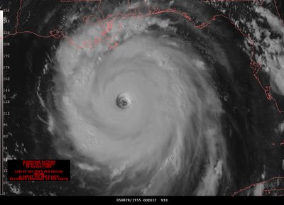
katrina

behold this awe, terror and respect-inspiring image. certainly quite ominous.
by 07:00 cdt on 28 august 2005, «hurricane katrina» was a category five storm, with maximum sustained winds of 280 km/h (175 mph), gusts up to 344 km/h (215 mph) and a central pressure of 902 mbar. it had reached category four intensity just after midnight, at 12:40 cdt with 233 km/h (145 mph) winds.
the mayor of new orleans, clarence ray nagin, jr, issued a mandatory evacuation order for all of the parish of orleans at 10:00 cdt.
can anyone imagine evacuating an area the size of the united kingdom in a matter of hours?
at 06:10 cdt, 29 august 2005, hurricane katrina made its second landfall as a category 3 hurricane near buras-triumph, louisiana, with sustained winds of more than 125 mph (201 km/h). katrina also made landfall in st bernard parish and st tammany parish for a total of three landfalls in louisiana.
by 8:00 cdt, in new orleans, water was seen rising water on both sides of the industrial canal.
by 09:00 cdt, there was 6-8 feet of water in the lower ninth ward.
at 10:00 cdt, the hurricane made its third landfall near pearlington, mississippi and slidell, louisiana, with sustained winds of 193 km/h (120 mph) after crossing breton sound.
by 11:00 cdt, there was approximately three metres (ten feet) of water in st bernard parish. many rooftops could not be seen here as they were submerged.
at 2:00 cdt, new orleans officials confirmed a breach of the 17th street canal levee. there was also confirmation of breaches at two other canals.
one thousand five hundred people lost their lives.
[entry unfinished. notes: seventy percent of hospitals in the area remain closed. some must travel eighty miles to reach a grocery store. the suicide rate has increased three-fold.]


